


Geotag Photos Pro 2

Geotag Photos Pro 2 açıklaması
Coğrafi etiket Fotoğrafları Pro, profesyonel coğrafi etiketleme çözümü - Eğer DIŞ kamera (DSLR, aynasız veya kompakt bir) tarafından çekilen fotoğrafları coğrafi etiket için gereken tüm. JPG ve RAW fotoğraf destekler ve veri coğrafi etiketli fotoğrafları destekler Lightroom, Aperture, Picasa ve diğer fotoğraf uygulamalar ile de kullanılabilir.
ÜCRETSİZ 3 gezileri deneyin ve sonra bir kez ücret karşılığında tam app kilidini.
Coğrafi Etiket Fotoğraflar Pro sektör uzmanları tarafından övgüyle
- Macworld Yılın Coğrafi Etiketleme Uygulaması
- Arka arkaya gelen Adobe Lightroom uzmanları tarafından tavsiye edilen
- Bu tür fotoğrafçılar için 4 yol haritası Lightroom 4 Unmasked, Lightroom 4 eksik SSS, Lightroom gibi birçok büyük kitaplarda önerilen
- Tüm dünyada fotoğrafçılık dergiler ve web siteleri lider tarafından övgüyelâyıktır (TechRadar, Ephotozine, Fotomaf, Xatakafoto, Lightroom Sırları, Digital-Fotografie, Pixelmania.nl, PhotoPlus ...)
Coğrafi Etiket Fotoğraflar hakkında en iyi gerçekler Pro
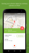
- Komple çözüm - Sen harika fotoğraflar alarak konum ve bir masaüstü uygulaması kaydedilen verileri kullanarak görüntüleri geotags ise mobil uygulaması konumunuzu kaydeder.
- Kusursuz Lightroom Uyumluluk - geotagging için Lightroom Harita modülünün içinde kusursuz uygulama işten GPX dosyaları
- Dropbox ve Google Drive desteği - otomatik GPX dosyaları gibi tüm geziler ihracat
- Akıllı izle app - özel uygulama bileğinizin gelen uygulamayı denetlemek için Android Wear ve Pebble için! Otomatik açma yükleme - app otomatik olarak tüm geziler (ayarlarda manuel yüklenenler geçebilirsiniz) senkronize
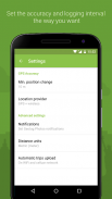
- Konum etiketleme bütün gün için optimize Pil kullanımı
- Ihtiyacınız ne olursa olsun için günlük aralığı ve doğruluğu seçin
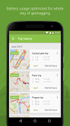
- Organize geziler geçmişi
- Senin gezileri İstatistikler
- GPX İhracat
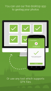
ÜCRETSİZ masaüstü coğrafi etiketleme uygulaması
Hızla ve kolayca sizin için JPG veya RAW fotoğraflara GPS konum ekler! Herhangi bir işletim sistemi için online ve offline ve orada sürümü hem İşleri - Mac OS X Windows ve Linux
Desteklenen resim formatları: jpg, nef, cr2, crw, dcr, CIFF, erf, orf, K25, kdc, mef, mrw, nrw, pef, raf, tif, tiff, çiğ, arw, RW2, srf, sr2, srw, x3f, dng
Http://www.geotagphotos.net fazla bilgi için web sitemizi ziyaret
Geotag Photos Pro 2 - Sürüm 3.0.0
(13-12-2022)
Geotag Photos Pro 2 - APK Bilgisi
APK sürümü: 3.0.0Paket: com.tappytaps.android.geotagphotospro2Geotag Photos Pro 2 uygulamasının en son sürümü
Diğer sürümler


Aynı kategorideki uygulamalar


Hoşuna gidebilecekler...


